
Roseville Previous Residents: Record Eras
An address history is strongest when records meet at the same parcel. The recorder shows transfer parties, but a deed does not prove that a buyer slept at the address. A directory or census places a person or household at a point in time, while assessment rolls and maps bridge older parcel lines. Test each source against another. Roseville's trail crosses the city, Placer County, the library, archives, and courts, so an online name result is only one part of the chain.
| Record source | Coverage | Keeper and access | Historical clue |
|---|---|---|---|
| Recorder grantor/grantee index | Current; online cutoff not stated | Placer County Clerk-Recorder; index online, images by office or order | Parties, document type, date, and reference |
| Deed books | 1851-1960 | County Archives; appointment | Grantors, grantees, legal descriptions, and title chain |
| Assessment rolls and maps | 1851-1961 | County Archives; appointment | Assessed party, parcel geography, and value |
| Roseville local directories | 1914-1999 checkpoints | Downtown Library Local History | Subscriber, resident, business, or address clues |
| Haines and EDR criss-cross evidence | 1971-2017 samples | Library/report evidence | Address-to-occupant snapshots |
| Federal census | Through 1950 | Library databases | Household enumeration at ten-year points |
| Probate and wills | Probate 1851-1960; wills through 1963 | County Archives; appointment | Deceased residents, estates, and heirs |
For recent transfers, start with the APN and recorder index. Older houses cross the 1960 archive line, then add directories, census, newspapers, obituaries, and probate.
Roseville's APN Starting Point
For a current Roseville house, begin with the Roseville Property Information Tool. Enter the address, choose GO, open Property Report, and record the APN. The report connects the location to parcel layers for subdivision, ZIP, neighborhood, zoning, and land use. It is a locational record, not an owner directory.
Take the APN to Placer Property Details. The county web search is APN-first, with no owner-name or street-address search. Request owner information with an APN or full address through the assessor contact channel or at 530-889-4300. That handoff gives the recorder a usable identifier.
| Field label | Type | Required | Roseville use |
|---|---|---|---|
| Fee Parcel Number | Parcel identifier | Available field | Use the APN from Property Report. |
| Assessment Number | Assessment identifier | Available field | Alternate parcel key. |
| Aircraft Tail Number | Separate identifier | Available field | Shown by the assessor search, but not a house identifier. |
| Acknowledgment | Agreement | Required | Select “Yes, I understand and agree.” |
The county APN is a 12-digit identifier. Keep it with the address and legal description, since later records may use another street form.
Roseville Past Residents in the Deed Chain
Once an APN is in hand, follow its transfer reference to the recorder index. Search the current owner as grantee, read the grantor, then search that seller as an earlier grantee. Each pass moves one transaction back. The goal is to identify parties tied to the parcel, not assume every owner was a resident.
- Enter the address in the Roseville Property Information Tool, open Property Report, and save the APN, legal-description clues, and transfer document or date.
- Use the county index to locate the current owner's acquisition. Compare the name, document type, recording reference, APN, and legal description.
- Take the grantor from that deed and search that person or entity as an earlier grantee. Repeat the handoff for each prior transfer.
- When the online trail stops, do not guess at a cutoff year. The county states that current index coverage is available, but the online imaging cutoff is not stated.
- Move older links to the recorder counter, an ordered copy, or County Archives deed books and assessment rolls. Compare the result with a directory or census household.
- Grantor and grantee
- The grantor conveys an interest. The grantee receives it. In a purchase deed, the seller is usually the grantor and the buyer the grantee.
- Chain of title
- The linked sequence of recorded transfers that connects later parties to earlier parties for one parcel.
- Legal description
- The recorded parcel wording, such as a lot or subdivision description. It can identify an old parcel when a street name or number changed.
A name match is not enough. Verify the APN and legal description at every break, because a street address may not be indexed and a tax parcel is not always the same as the recorded legal lot.
Roseville's Recorder Index Beyond the Web
The Placer County real-property record channel maintains a daily grantor/grantee index cross-referenced by party name, document type, document number, and date or reference. The current index locates transfers, but its online cutoff is not stated. Scanned deed images are not online. View or order them at the research counter Monday through Friday, 8 a.m. to 4 p.m.
A noncertified copy costs $2 for the first page and $1 for each additional page. A certified copy costs $4 for the first page and $1 for each additional page. Fax or email service is $4.25. Mail requests should name the document type, parties, recording number or reference, phone, and return address, include a check or money order, and preferably include a legal-size self-addressed stamped envelope. Mail goes to 3715 Atherton Rd, Rocklin, CA 95765; the office number is 530-886-5600.
Note: A recorder index reference can locate a deed image, but the online index alone does not display the image.
Roseville House History for Past Residents
When the deed chain reaches older material, use the Placer County Archives at 11523 C Ave, Auburn. Appointments are Monday and Tuesday, 9 a.m. to noon and 1 to 3 p.m.; the research phone is 530-889-7789. Auburn is the county seat, so a Roseville house history often leaves the city for its oldest title records.
The archive holds deeds from 1851-1960, assessment rolls and maps from 1851-1961, probate from 1851-1960, wills through 1963, and naturalizations from 1852 to about 1960. Placer's surviving record core begins in 1851, and no official courthouse-fire loss was located. Sanborn maps may help with building footprints, but exact Roseville years were not confirmed. Permit and planning records can add applicants, contractors, and dates, yet online coverage was not established. The Roseville City Clerk is the public-records request channel for that gap.
Note: An unconfirmed map year is a research gap, not permission to assign a Sanborn date to a Roseville parcel.
Roseville Previous Residents in Print
Directories supply the household layer deeds lack. The Roseville library directory catalog identifies local volumes from 1914 through 1999 checkpoints: the 1914 and 1922 telephone books, Tribune and Register business material from 1925-26, a numerical telephone and classified guide from 1929-30, a Chamber directory around 1947, the 1948 Roseville and Railroads Gold Centennial, the November 1956 telephone directory, and a 1999 Chamber membership directory.
The 1914 catalog record describes one unpaged illustrated 20-centimeter reproduction in Downtown Library reference storage at R2-C3-S4-B1. Haines and EDR criss-cross evidence is documented for 1971, 1977, 1981, 1986, 1990, 1992, 1995, 2000, 2005, 2010, 2014, and 2017. These address-first editions show occupant snapshots, but an omission means only that the person or street was absent from that edition.
Polk editions from 1963 and 1966 did not list Vineyard Road, while later Haines and EDR material records 2351 and 2359 Vineyard Road in 2017. That contrast marks a source limit, not proof that a street had no Roseville residents.
Roseville Past Households and Census Years
Ownership and occupancy are separate questions. A criss-cross directory can put a person at a street number, while a census records a household at an enumeration point. The shelf details belong on the Roseville Directory Book page; the address-history task pairs those collections with census and deed evidence.
- Choose the directory nearest the year of interest. Search the surname alphabetically, then switch to the address-first or criss-cross section to separate namesakes.
- Pair the 1914 directory with the 1910 and 1920 censuses. Pair the 1922-30 material with 1920 and 1930.
- Pair the 1948 and 1956 checkpoints with 1940 and 1950. Compare the household members, address form, and parcel clues rather than copying one name forward.
- Treat 1950 as the latest public census in the available record set. The 1960 census release is scheduled for April 1, 2032.
- Close gaps with the next directory, deed chain, probate file, newspaper item, or obituary. A person disappearing from one directory may have moved, died, or simply not appeared in that volume.
The result is a bracket, not a daily log. Directory and census years are separate snapshots; agreement across both is stronger than either source alone.
Lawful house history. Previous-resident research belongs to family history, genealogy, estate and heir work, and personal curiosity. Record access does not permit stalking, harassment, threats, or attempts to expose a protected address.
Roseville Heirs, Obituaries, and Past Residents
Probate and obituary work can finish a household trail after a resident has died or left. County probate files and wills may name heirs, executors, or property interests. The Roseville library database list links to Heritage Hub, with obituaries and death notices from 1824 to the present, and local newspaper resources. Press-Tribune clippings begin in 1920 in-library. Check a notice's name, date, spouse, relative, or former address against the parcel and court record.
The Roseville Historical Society accepts research requests and reports ongoing archive scanning and newspaper indexing. Narrow the person and date with a death notice, then test the relationship in probate, a will, or a recorded transfer. An heir connection explains family ties; it does not prove occupancy or residence at a mailing address.
Note: Probate can identify heirs tied to an estate, but it cannot by itself establish a person’s day-to-day occupancy at a Roseville address.
Roseville Address and Parcel Continuity
Before calling someone a past resident, test whether the address stayed stable. Roseville streets and numbers may read differently in a modern map and an older deed. The address may not appear in the recorder index, and a 12-digit tax parcel is not necessarily the recorded legal lot. Use the APN, subdivision or lot wording, and legal description together. A mailing address is where assessment correspondence goes; the situs address is the physical parcel. Their difference is a clue, not proof of occupancy.
Names can mislead too. Fiddyment, Cirby, Kaseberg, Buljan, Astill, Doyle, and Mahany are Roseville place names and family names, so a person search can collide with a street or subdivision search. Modern west-side addresses often call for subdivision maps, permits, and GIS rather than early directories. For a named street, the Roseville Street Directory keeps current parcel steps in order.
Roseville Deed Alerts for Past Residents
Since 2024, Placer Recorder has automatically mailed the owner of record after a deed or other ownership-affecting document is recorded. The real-property fraud notification includes the first page and 916-645-SCAM hotline. It can flag a new transfer, but it is not a previous-resident list and does not replace deed-chain research.
The federal case trail is supplementary. The June 26, 2026 PACER fee announcement supplies the fee context for the federal record route shown below.
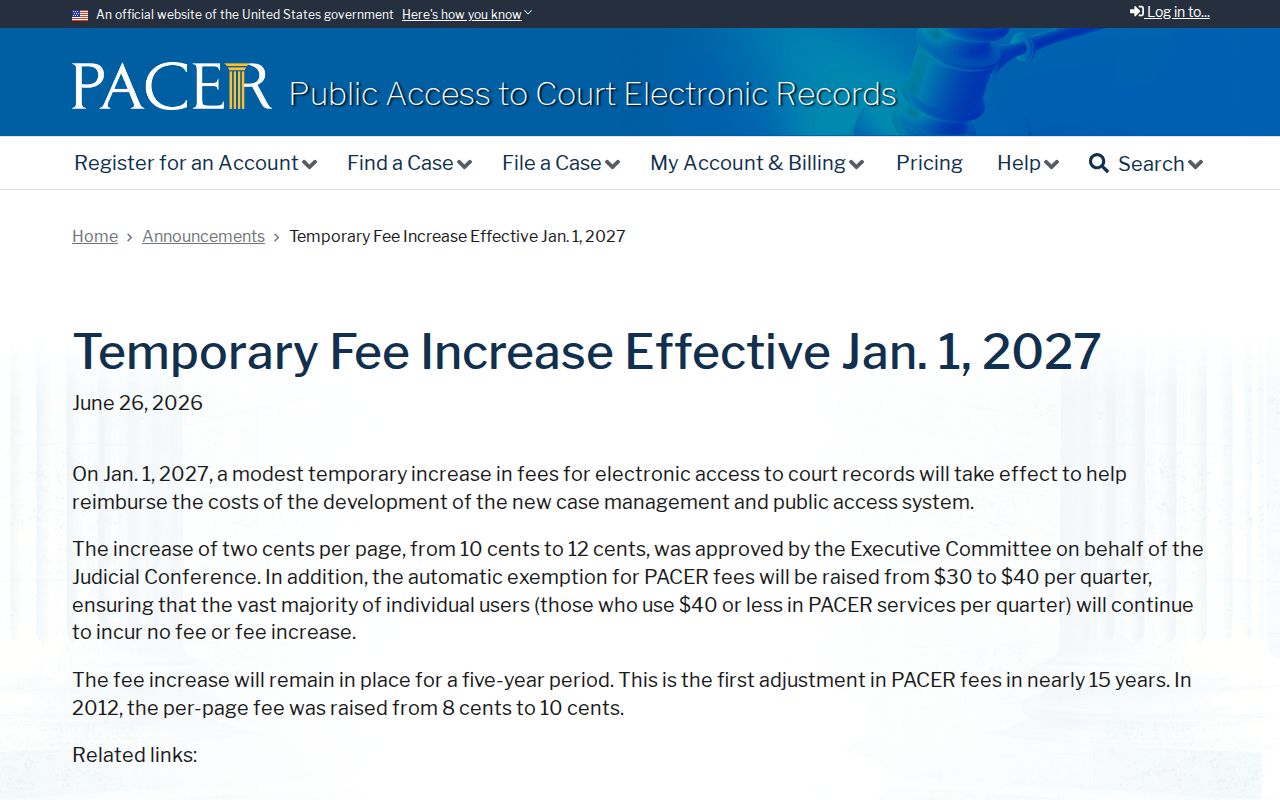
In 2026, PACER normally charges $0.10 per page, usually capped at $3 per document or report, and quarterly charges of $30 or less are waived. The notice says a temporary rate of $0.12 per page and a $40 waiver threshold will begin January 1, 2027. Name searches and transcripts can be uncapped. A federal case can supplement a Roseville address history when a person or estate appears in federal litigation, but Placer deeds, archives, directories, probate, and obituaries remain the core trail.